Global Navigation Satellite System; Vertical Land Movements; Sea Level Rise; Surveying; Precise Levelling; Tide Gauge
Abstract :
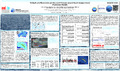
[en] South Georgia Island in the Southern Atlantic Ocean is a key location for the seismic, geomagnetic and oceanic global monitoring networks. In its sub-Antarctic location, the island is largely covered by mountain glaciers which have been reported to be retreating due to climatic change. Furthermore, during past glaciation periods the island and its shelf area have been ice covered as was revealed by scarring of the sub-oceanic topography. Together with ongoing tectonics along the North Scotia Ridge, these processes have the ability to produce significant uplift on local to regional scales, affecting the measurements of the tide gauge (GLOSS ID 187) at King Edward Point
(KEP). Furthermore, with its mid-ocean location, the tide gauge is of particular interest to satellite altimetry calibrations over the Southern Atlantic and Southern Oceans. With the establishment of five GNSS stations on the islands during 2013 to 2015 and the scientific analysis of these data within the global network of stations of the International GNSS Service Tide Gauge Benchmark Monitoring (TIGA) working group, it has now become possible to study present-day vertical land movements of the region and their impacts on, for example, regional sea level. Furthermore, together with four precise levelling campaigns of the KEP benchmark network in 2013, 2014 and two in 2017, it has also been possible to investigate the very local character of the vertical motions near KEP, ie. the stability of the jetty upon which the tide gauge is mounted.
In this study, we will present the still preliminary results from the GNSS and levelling measurements and will discuss their impact on the sea level record from the KEP tide gauge. Our measurements show that while South Georgia Island and the area around KEP are rising, the jetty and tide gauge are subsiding, leading to a disagreement in the observed sea level change from the tide gauge and satellite altimetry. In order to improve the agreement between these sea level measurements both local and regional vertical land movements need to be monitored.
Research center :
ULHPC - University of Luxembourg: High Performance Computing
Disciplines :
Earth sciences & physical geography
Author, co-author :
TEFERLE, Felix Norman ; University of Luxembourg > Faculty of Science, Technology and Communication (FSTC) > Engineering Research Unit
HUNEGNAW, Addisu ; University of Luxembourg > Faculty of Science, Technology and Communication (FSTC) > Engineering Research Unit
ABRAHA, Kibrom Ebuy ; University of Luxembourg > Faculty of Science, Technology and Communication (FSTC) > Engineering Research Unit
Woodworth, Phil; National Oceanography Centre Liverpool
Williams, Simon; National Oceanography Centre Liverpool
Hibbert, Angela; National Oceanography Centre Liverpool
Smalley, Robert; University of Memphis > Center for Earthquake Research and Information
Dalziel, Ian; University of Texas at Austin > Jackson School of Geosciences
Lawver, Larry; University of Texas at Austin > Jackson School of Geosciences
External co-authors :
yes
Language :
English
Title :
Vertical Land Movements and Sea Level Changes around South Georgia Island
Publication date :
09 April 2018
Number of pages :
1,8 x 1,1 m
Event name :
European Geosciences Union General Assembly 2018
Event organizer :
European Geosciences Union
Event place :
Vienna, Austria
Event date :
08-04-2018 to 13-04-2018
Audience :
International
Focus Area :
Sustainable Development Computational Sciences
FnR Project :
FNR6835562 - Multi-gnss Benefits To Long-term Monitoring Applications In The Geosciences, 2013 (01/05/2014-30/04/2018) - Kibrom Ebuy Abraha
Name of the research project :
R-AGR-0376 - IRP15 - SGSL (20150501-20170430) - TEFERLE Felix Norman
Funders :
University of Luxembourg - UL FNR - Fonds National de la Recherche