Abstract :
[en] Modern cities all over the world are now more susceptible to flash floods as a result of a rise in the frequency and severity of meteorological events with significant precipitation. For minimizing the risks due to these hydro-meteorological hazards, reliable fore- and now-casting of severe precipitation has become essential. Water vapor can be measured along slant paths by network of ground-based GNSS stations, providing real-time, three-dimensional (3D) distributions of vapor concentrations at an affordable cost. Consequently, these data provide an invaluable additional source of knowledge for monitoring and predicting events with flash flood potential. But site-specific multipath (MP) effects at GNSS stations do affect incoming signals, particularly at low elevations, as is widely known. The bulk of GNSS products for meteorology up to now are based on estimates of ordinary zenith total delay and horizontal gradients with little sensitivity to azimuthal variations, thus these products may not be best suited for estimating 3D distributions of water vapor during storm events. Using slant delays directly, can overcome this lack of azimuthal information. However, at low elevations, this approach is more susceptible to multipath errors.
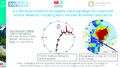
A thunderstorm event which occurred over Turkey and adjacent countries on July 27, 2017, resulting in flash floods and severe infrastructure damage, is used as an example to explore the effects of multipath-corrected slant wet delay (SWD) estimations on monitoring extreme weather events. To reconstruct the one-way SWD, we first added phase residuals derived from the GNSS one-way post-fit observations, which represent the anisotropic component of the SWD. This can also be interpreted as a higher order inhomogeneity component, which is not resolved by ordinary zenith or gradient products. For the generation of site-specific MP correction maps, we stacked the post-fit residuals derived from our Precise Point Positioning (PPP) processing strategy because the MP errors in the GNSS phase observables can adversely impact the SWD along the direction of individual satellites. The spatial stacking was performed in congruent cells as a function of elevation and azimuth. This enables each cell to receive roughly the same number of residuals, providing a better stacking result. The stacking of residuals for a single cell over several days allows the detection and reduction of systematic errors; random errors are minimal because the averaging is done over a suitably sufficient chosen time span. Finally, the one-way SWD were enhanced by applying these MP correction maps for the analysis of the meteorological event.
Our study revealed that the anisotropic component contributed up to 11% of one-way SWD estimates. Furthermore, the spatio-temporal changes in SWD as derived from GNSS closely matched the moisture field from the ERA5 re-analysis linked to this weather event. As it turns out, the MP correction maps may also provide a “kind of calibration” for uncalibrated or low-cost GNSS antennas, even for those in mobile phones, as these devices are highly susceptible to MP errors. In turn, this would allow the application of low-cost sensors to accurately estimate SWD for severe weather monitoring in urban regions.
Name of the research project :
Advanced Asymmetry Tropospheric Products For Meteorology From Gnss And Sar Observations (VAPOUR)