[en] The vadose zone of karst systems plays an important role on the water dynamics. In particular, temporary perched aquifers can appear in the subsurface due to changes of weather conditions, reduced evapotranspiration and the vertical gradients of porosity and permeability.
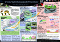
Although many difficulties are usually encountered when studying karst environments due to their heterogeneities, cave systems offer an outstanding opportunity to investigate vadose zone from the inside. We present a multi-scale study covering two years of hydrogeological and geophysical monitoring of the Lomme Karst System (LKS) located in the Variscan fold-and-thrust belt (Belgium), a region (∼3000 ha) that shows many karstic networks within Devonian limestone units.
Hydrogeological data cover the whole LKS and involve e.g. flows and levels monitoring or tracer tests performed in both vadose and saturated zones. Such data bring valuable information on the hydrological context of the studied area at the catchment scale. Combining those results with geophysical measurements allows validating and imaging them at a smaller scale, with more integrative techniques.
Hydrogeophysical measurements are focused on only one cave system of the LKS, at the Rochefort site (∼40 ha), taking benefit of the Rochefort Cave Laboratory (RCL) infrastructures. In this study, a microgravimetric monitoring and an Electrical Resistivity Tomography (ERT) monitoring are involved.
The microgravimetric monitoring consists in a superconducting gravimeter continuously measuring gravity changes at the surface of the RCL and an additional relative gravimeter installed in the underlying cave located 35 meters below the surface. While gravimeters are sensible to changes that occur in both the vadose zone and the saturated zone of the whole cave system, combining their recorded signals allows enhancing vadose zone’s gravity changes.
Finally, the surface ERT monitoring provide valuable information at the (sub)-meter scale on the hydrological processes that occur in the vadose zone. Seasonal water variations and preferential flow path are observed. This helps separating the hydrological signature of the vadose zone from that of the saturated zone.
Disciplines :
Earth sciences & physical geography
Author, co-author :
Watlet, Arnaud
Poulain, Amaël
FRANCIS, Olivier ; University of Luxembourg > Faculty of Science, Technology and Communication (FSTC) > Engineering Research Unit
Hallet, Vincent
Kaufmann, Olivier
Quinif, Yves
Rochez, Gäetan
Triantafyllou, Antoine
Van Camp, Michel
External co-authors :
yes
Language :
English
Title :
Multiscale hydrogeological and hydrogeophysical approach to monitor vadose zone hydrodynamics of a karst system
Publication date :
2016
Event name :
European Geophysical Union General Assembly 2016
Event organizer :
EGU
Event place :
Vienna, Austria
Event date :
from 17-04-2016 to 22-04-2016
Audience :
International
Focus Area :
Sustainable Development
Commentary :
Recieved the Outstanding Student Poster and PICO (OSPP) Award contest at the EGU General Assembly 2016