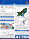
[en] Floods are one of the most widespread natural disasters worldwide. In 2022, Pakistan faced a catastrophic humanitarian crises caused by severe floods resulting from monsoon rains that exceeded five times the 30-year average. The flood affected more than a third of the country's landmass and impacted over 33 million people.Using reflected L-band Global Navigation Satellite System (GNSS) signals is an alternative remote sensing method to detect and monitor floods. This method, known as GNSS Reflectometry (GNSS-R), repurposes signals to determine surface properties of the area from which they are reflected. These signals are sensitive to variations in biogeophysical parameters, making them a useful tool for flood detection and monitoring.
A track-wise method is proposed in this work to map the flood extent over Pakistan in August 2022 using Cyclone GNSS (CYGNSS) L1 v3.1 observations. The proposed method is not affected by variations in the transmitted signal power or angle of incidence.