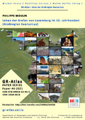
[de] Mit dieser Karte wird der Versuch einer kartographischen Darstellung der aktiven Lehen der Grafen von Luxemburg zwischen 1200 und 1310 unternommen. Die Karte wurde im Rahmen der Masterarbeit „Lehnsrecht, Lehnspolitik und Lehnshof der Grafen von Luxemburg im 13. Jahrhundert“ erstellt und soll Präsenz, Häufigkeit und Art von Lehnsgütern der Grafen von Luxemburg visualisieren. [fr] La carte „Les fiefs des comtes de Luxembourg au 13ème siècle“ représente l’essai d’une visualisation cartographique des fiefs actifs des comtes de Luxembourg entre 1200 et 1310. La carte a été créée dans le cadre du mémoire de Master « Lehnsrecht, Lehnspolitik und Lehnshof der Grafen von Luxemburg im 13. Jahrhundert » et a comme but la visualisation de la présence, le nombre et le type de fiefs. [en] The map "The fiefs of the counts of Luxembourg in the 13th century" represents an attempt at a cartographic visualisation of the active fiefs of the counts of Luxembourg between 1200 and 1310. The map was created within the framework of the Master thesis "Lehnsrecht, Lehnspolitik und Lehnshof der Grafen von Luxemburg im 13. Jahrhundert" and aims to visualise the presence, number and type of fiefs.
Disciplines :
History
Author, co-author :
Moulin, Philippe
Editor :
PAULY, Michel ; University of Luxembourg > Faculty of Humanities, Education and Social Sciences > Department of Humanities > History
CARUSO, Geoffrey ; University of Luxembourg > Faculty of Humanities, Education and Social Sciences (FHSE) > Department of Geography and Spatial Planning (DGEO)
HELFER, Malte ; University of Luxembourg > Faculty of Humanities, Education and Social Sciences (FHSE) > Department of Geography and Spatial Planning (DGEO)
Language :
German
Title :
Lehen der Grafen von Luxemburg im 13. Jahrhundert (Großregion SaarLorLux)
Alternative titles :
[fr] Fiefs des comtes de Luxembourg au 13e siècle (Grande-Région SaarLorLux)
Publication date :
2021
Publisher :
Department of Geography and Spatial Planning - University of Luxembourg, Esch-Belval, Luxembourg