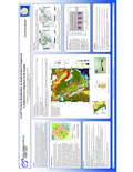
[en] Current investigations of the motions of the Arabian and its neighboring plates are primarily based on GPS measurements obtained in the surrounding areas of the Arabian plate, with few stations actually located on the Arabian plate itself in the Kingdom of Saudi Arabia. In order to advance the knowledge of the dynamics of the Arabian plate and its intra-plate deformations, the General Directorate of Military Survey (GDMS), through a collaboration with the Institute of Engineering Surveying and Space Geodesy (IESSG), densified the GPS network in Saudi Arabia, covering nearly two thirds of the tectonic plate. Since July 2002, a network of 32 GPS stations has been established at locations of the Saudi Arabia geodetic network. At all of these GPS stations a concrete pillar has been used as the monument and the locations have been selected in order to give the broadest distribution of observing sites. During 2005, 27 additional GPS stations in the Hejaz and Asser Mountains in the south-western part of Saudi Arabia, have been established, with the GDMS GPS network now comprising a total of 59 stations. In this presentation we will introduce the new GPS network in Saudi Arabia established by GDMS and will present the initial results from campaigns in March 2003 and March 2005. We show preliminary estimates of absolute and relative Arabian plate motions inferred from the GPS network and a detailed comparison of the results based on the Bernese GPS software versions 4.2 and 5.0.