Global Navigation Satellite System; Sea Level; Vertical Land Movement; International GNSS Service; Tide Gauge
Abstract :
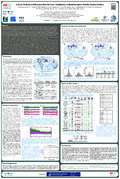
[en] Coastal sea-level measurements by tide gauges provide the longest instrumental records of sea-levels with some stretching from the 19th century to present. The derived mean sea-level (MSL) records provide sea-level relative to a nearby tide gauge benchmark (TGBM), which allows for the continuation of this record in time after, for example, equipment modifications. Any changes in the benchmark levels induced by vertical land movements (VLM) affect the MSL records and hence the computed sea-levels. In the past, MSL records affected by VLM were often excluded from further analyses or the VLM were modelled using numerical models of the glacial isostatic adjustment (GIA) process. Over the last two decades Global Navigation Satellite System (GNSS), in particular Global Positioning System (GPS), measurements at or close to tide gauges and the development of the associated processing strategies, have made it possible to obtain estimates of VLM in a geocentric reference system, such as the International Terrestrial Reference Frame release 2008 (ITRF2008) that approach the required accuracy for sea-level studies. Furthermore, the GPS-derived VLM estimates have been shown to improve estimates of sea-level change compared to those using the aforementioned GIA models as these models cannot predict local subsidence or uplift.
The International GNSS Service (IGS) Tide Gauge Benchmark Monitoring (TIGA) Working Group has recently re-processed the global GNSS data set from its archive (1000+ stations for 1995-2014) to provide VLM estimates tuned for the sea-level community. To achieve this, five TIGA Analysis Centers (TAC) contributed their reprocessed global GPS network solutions to the WG, all employing the latest bias models and processing strategies in accordance with the second re-processing compaign (repro2) of the IGS. These individual solutions were then combined by the TIGA Combination Center (TCC) to produce, for the first time, a TIGA combined solution (Release 0.99). This combined solution allows an evaluation of each individual TAC solution while also providing a means to gauge the quality and reliability of the combined solution, which is generally regarded as superior to the individual TAC solutions. Using time series analysis methods, estimates of VLM can then be derived from the daily position estimates, which are sub-sequentially employed to investigate coastal sea-levels. In this study, we show results from the evaluation of the relevant solutions, provide an evaluation of the TIGA VLM estimates and give examples of their impact on sea-level estimates for selected tide gauges from around the world. The TAC and TIGA combined solutions, as well as the derived VLM data sets are available from the IGS TIGA WG and will be accessible through SONEL (www.sonel.org) in the near future.
Research center :
ULHPC - University of Luxembourg: High Performance Computing
Disciplines :
Earth sciences & physical geography
Author, co-author :
HUNEGNAW, Addisu ; University of Luxembourg > Faculty of Science, Technology and Communication (FSTC) > Engineering Research Unit
TEFERLE, Felix Norman ; University of Luxembourg > Faculty of Science, Technology and Communication (FSTC) > Engineering Research Unit
ABRAHA, Kibrom Ebuy ; University of Luxembourg > Faculty of Science, Technology and Communication (FSTC) > Engineering Research Unit
Bingley, Richard; British Isles continuous GNSS Facility (BIGF)
Hansen, Dionne
Deng, Zhiguo; GFZ Potsdam
Schöne, Tilo; GFZ Potsdam
Santamaria-Gomez, Alvaro; University of La Rochelle
Gravelle, Médéric; University of La Rochelle
Wöppelmann, Guy; University of La Rochelle
Sanchez, Laura; DGFI Technical University of munich