Near Field Dynamic, Co-seismic and Post-seismic Deformations Associated with the 2013, M7.8, and 2003, M7.6, South Scotia Ridge Earthquakes Observed with GPS - 2014
Poster (Scientific congresses, symposiums and conference proceedings)
Near Field Dynamic, Co-seismic and Post-seismic Deformations Associated with the 2013, M7.8, and 2003, M7.6, South Scotia Ridge Earthquakes Observed with GPS
Smalley, Robert Jr; Bevis, Mike G; Zakrajsek, A Fet al.
2014 • XXXIII SCAR Biennial Meetings Including the 2014 Open Science Conference
Global Positioning System; South Scotia Ridge; Earthquakes
Abstract :
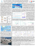
[en] The South Scotia Ridge (SSR) left-lateral transform/strike-slip (S-S) fault defines the Scotia plate’s (SP) southern boundary separating it from the Powell Basin (PB), South Orkney Microcontinent (SOM), and the Weddell Sea sections of the Antarctic plate (AP). The SP developed as a space filling accommodation zone for S. America-Antarctica relative motions, mostly during the last 40 m.y. The SSR also hosts several restraining and releasing bends. The SP, PB and SOM have complex evolution histories including large-scale displacement and stretching of the SOM, as well as other continental fragments within the SP, all of which were incorporated into a background of changing sea floor spreading geometries.
The SOM defines an ~300 km segment of the SSR opposite a section of the SP that is primarily oceanic crust with a few small, stretched continental fragments. Two large earthquakes, M7.6 and 7.8, with aftershock zones largely confined to the northern SOM boundary, occurred on the SSR in 2003 and 2013. Moment tensor solutions show they occurred on faults dipping ~30 and 45° to the south. The 2013 event was almost pure, left-lateral strike-slip, while the 2003 event was oblique but predominantly strike-slip. This is an unusual combination of fault dip and slip direction for a strike-slip plate boundary. The half duration of both events is also relatively long.
A continuous GPS (CGPS) station on Laurie Island is located immediately west of the rupture zone of the 2003 event and at the approximate center, and close to the surface projection, of the finite fault models for the 2013 earthquake. We present co-seismic static offsets and post-seismic transients for both earthquakes from GPS daily position estimates. In addition, the CGPS station now records at 1 Hz and we present the GPS displacement seismogram for the 2013 event. This record contains a complex signal that includes the passage of the Love and Rayleigh surface waves, with max displacements of ~70 cm, over an ~80 second time interval during which a ~50 cm static offset developed.
Disciplines :
Earth sciences & physical geography
Author, co-author :
Smalley, Robert Jr; University of Memphis
Bevis, Mike G; The Ohio State University
Zakrajsek, A F; Instituto Antarctico Argentino
TEFERLE, Felix Norman ; University of Luxembourg > Faculty of Science, Technology and Communication (FSTC) > Engineering Research Unit
Dalziel, I W D; University of Texas at Austin
Lawver, L A; University of Texas at Austin
Larter, R D; British Antarctic Survey
External co-authors :
yes
Language :
English
Title :
Near Field Dynamic, Co-seismic and Post-seismic Deformations Associated with the 2013, M7.8, and 2003, M7.6, South Scotia Ridge Earthquakes Observed with GPS
Publication date :
September 2014
Event name :
XXXIII SCAR Biennial Meetings Including the 2014 Open Science Conference
Event organizer :
Scientific Committee on Antarctic Research
Event place :
Auckland, New Zealand
Event date :
23-08-2014 to 03-09-2014
Audience :
International
Name of the research project :
F1R-ING-PUL-12GSCG > GSCG > 01/04/2012 - 31/03/2015 > TEFERLE Felix Norman
Funders :
The contribution of the luxembourgish partner was funded by the University of Luxembourg