
  | TEFERLE, F. N., WIENEKE, L., PARVAZ, S., Bebon, Q., & BACKES, D. (05 May 2022). Scanning the Past: A 3D Model of Trausch's Library [Paper presentation]. Producing Histography in a Changing World - Practices of Historians in Analog and Digital Contexts, Luxembourg and Esch-sur-Alzette, Luxembourg. |
  | Mateo‑Garcia, G., Veitch‑Michaelis, J., Smith, L., Oprea, S., Schumann, G., Gal, Y., Baydin, A. G., & BACKES, D. (31 March 2021). Towards global flood mapping onboard low cost satellites with machine learning. Scientific Reports, 11 (7249 (2021)). doi:10.1038/s41598-021-86650-z  Peer Reviewed verified by ORBi Peer Reviewed verified by ORBi |
 | BACKES, D., & TEFERLE, F. N. (2020). Multiscale Integration of High-Resolution Spaceborne and Drone-Based Imagery for a High-Accuracy Digital Elevation Model Over Tristan da Cunha. Frontiers in Earth Science. doi:10.3389/feart.2020.00319 Peer Reviewed verified by ORBi |
 | BACKES, D., Smigaj, M., Schimka, M., Zahs, V., Grznárová, A., & Scaioni, M. (12 August 2020). RIVER MORPHOLOGY MONITORING OF A SMALL-SCALE ALPINE RIVERBED USING DRONE PHOTOGRAMMETRY AND LIDAR. The International Archives of the Photogrammetry, Remote Sensing and Spatial Information Sciences, XLIII-B2-2020 Article Metrics Related articles (1017), 1024. doi:10.5194/isprs-archives-XLIII-B2-2020-1017-2020 Peer reviewed |
 | Khalil, A., Stravoravdis, S., & BACKES, D. (2020). Categorisation of building data in the digital documentation of heritage buildings. Applied Geomatics. doi:10.1007/s12518-020-00322-7 Peer reviewed |
 | BACKES, D., Schumann, G., & TEFERLE, F. N. (11 December 2019). Conventional EO Satellites vs. CubeSats; FDL - AI flood detection onboard a Nano Satellite [Paper presentation]. 30th International Conference and AGM, Geological Remote Sensing Group (GRSG), Rome, Italy. |
 | Mateo-Garcia, G., Oprea, S., Smith, L., Veitch-Michaelis, J., Schumann, G., Gal, Y., Baydin, A., & BACKES, D. (October 2019). Flood Detection On Low Cost Orbital Hardware [Paper presentation]. Artificial Intelligence for Humanitarian Assistance and Disaster Response Workshop, 33rd Conference on Neural Information Processing Systems (NeurIPS 2019), Vancouver, Canada. |
 | BACKES, D., HASSANI, S. A., TEFERLE, F. N., & Schumann, G. (11 September 2019). A comparison between conventional Earth Observation Satellites and CubeSats; Requirements, Capabilities and Data Quality [Paper presentation]. 11th European CubeSat Symposium, Belval, Luxembourg. |
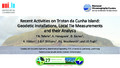 | TEFERLE, F. N., HUNEGNAW, A., BACKES, D., Hibbert, A., Williams, S. D. P., Woodworth, P. L., & Pugh, J. P. (11 July 2019). Recent Activities on Tristan da Cunha Island: Geodetic Installations, Local Tie Measurements and their Analysis [Paper presentation]. 27th IUGG General Assembly, Montréal, Canada. |
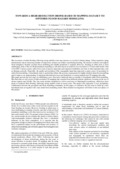 | BACKES, D., Schumann, G., TEFERLE, F. N., & Boehm, J. (June 2019). Towards a high-resolution drone-based 3D mapping dataset to optimise flood hazard modelling. International Archives of the Photogrammetry, Remote Sensing and Spatial Information Sciences, XLII-2/W13, 181-187. doi:10.5194/isprs-archives-XLII-2-W13-181-2019 Peer Reviewed verified by ORBi |
BACKES, D., & TEFERLE, F. N. (09 April 2019). Integration of high-resolution space-borne and terrestrial topographic data sets - Case study Tristan da Cunha [Poster presentation]. European Geoscience Union General Assembly 2019, Vienna, Austria. |
BACKES, D., & TEFERLE, F. N. (12 December 2018). Merging DEMs from VHR Optical Imagery with Drone Data - A High-resolution DEM for Tristan da Cunha [Paper presentation]. GRSG 2018 Annual Conference, London, United Kingdom. |
BACKES, D. (26 June 2018). Case Study 'Lunar Water and Volatiles' - Lunar resources prospecting with AI [Paper presentation]. FDL-Europe; boot camp, Rome - Frascati, Italy. |
 | BACKES, D., TEFERLE, F. N., ABRAHA, K. E., & BRUYÈRE, C. (10 April 2018). Towards multiscale data fusion of high-resolution space borne and terrestrial datasets over Tristan da Cunha [Poster presentation]. European Geoscience Union General Assembly 2018, Vienna, Austria. |
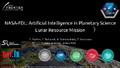 | BACKES, D. (15 December 2017). NASA-FDL Artificial Intelligence in Planetary Science; Lunar Resource Mission [Paper presentation]. GRSG 2017 Annual Conference, Lisbon, Portugal. |
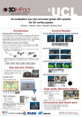 | BACKES, D., Teasdale, O., & Eloff, J. (22 September 2016). An evaluation of low-cost consumer-grade UAS systems for 3D reality capture [Poster presentation]. 2nd Virtual Geoscience Conference (VGC), Bergen, Norway. |